New Jersey Property Fax
Tideland Searches
Horror stories abound when dealing with properties with Tidelands claims. Home owners trying to sell their homes locked in endless litigation over State owned riparian land. Others still, thinking they have equity in their home, find it wiped out by “back owed” license or grant fees.
Potential deals squashed after months of negotiations by hidden issues relating to riparian rights. Time unnecessarily wasted by Real Estate professionals, home owners, and sellers.
Tidelands are “riparian rights and claims” established by the State of New Jersey to property lying in areas presently or formerly flowed by tidal waters. Tidelands Act (N.J.S.A. 12:3).
Tidelands claims and are found in 17 of 21 counties in New Jersey.
Perform a Tidelands Search for peace of mind.
NJ Property Fax will initiate a search for possible Tidelands claims on your property and if a grant or license exists that may attest to the fact, that the property is free from all State Tidelands claims or is properly licensed.
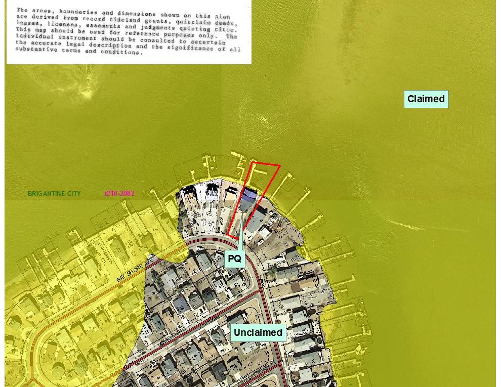
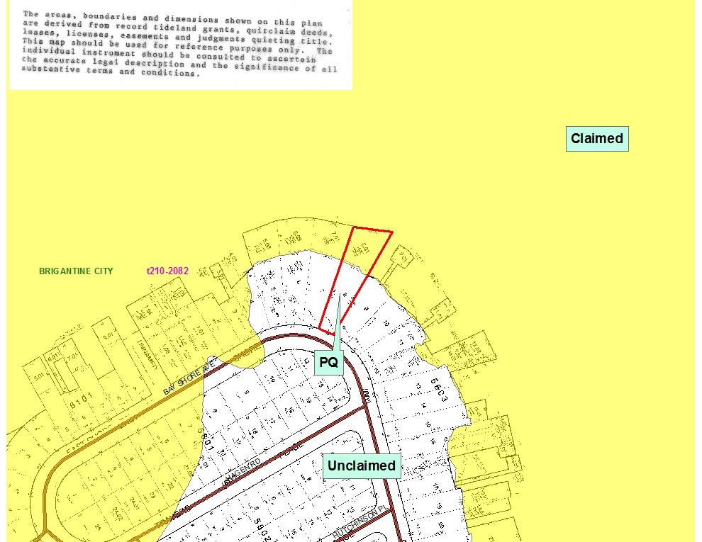
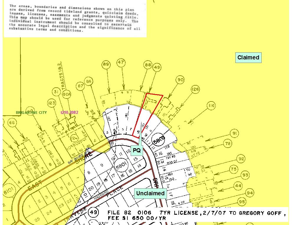
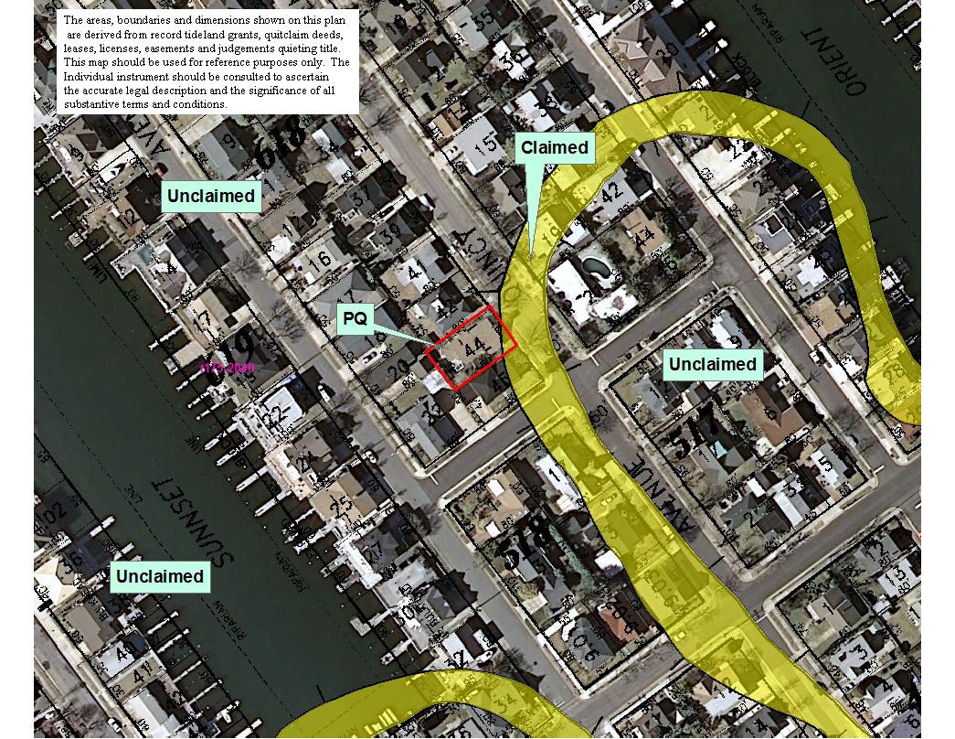
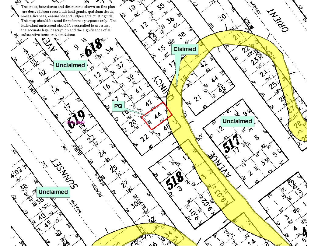
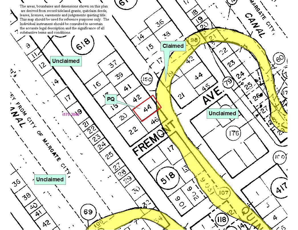
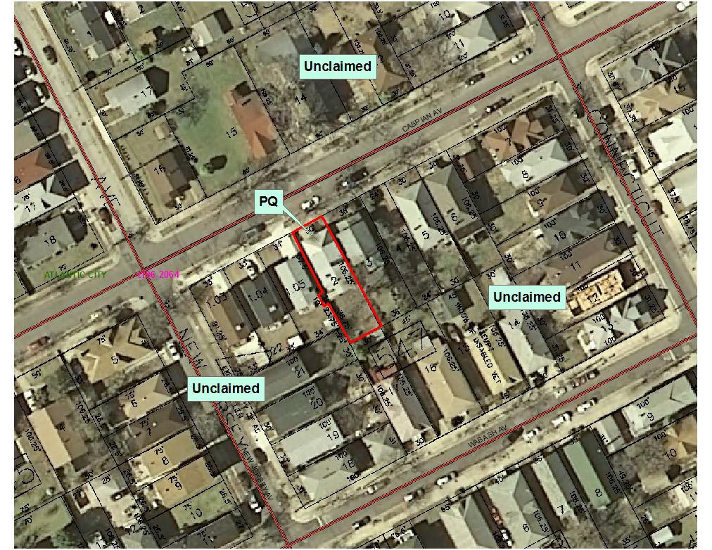
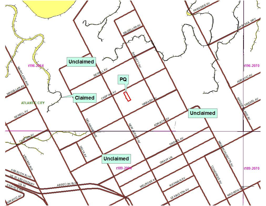
A report in pdf form is emailed to you within 24 hours, most reports are completed within a few hours. The report consists of the following map overlays:
- Property Boundaries
- Aerial Photography
- Street Maps
- Tidelands Boundaries
Tidelands/Riparian lands - Questions and Answers (show/hide all)
-
What are tidelands?Tidelands, also known as riparian lands, are all lands that are currently and formerly flowed by the mean high tide of a natural waterway. For example, Barnegat Bay, a naturally tidal body of water, is tidelands. Also tidelands, however, is New Creek, a tiny tidal stream that flowed through the city of Newark a century ago but has since been filled in and built over. New Jersey contains an extensive network of tidelands, both big and small.
-
Who owns the tidelands?
The State of New Jersey claims ownership of these tidelands and holds them in trust for the people of the state. The management of the tidelands is overseen by the Tidelands Resource Council, a twelve member Governor‐appointed board of volunteers, along with DEP staff at the Bureau of Tidelands Management.
Since tidelands are public lands, you must obtain written permission from the State and pay a fee in order to use these lands. Some tidelands may be sold in the form of a Riparian Grant while others may only be rented through either a Tidelands License or Lease.
All money that is collected from the sale and rental of tidelands is deposited into a trust fund for State education and is also used as a guaranty against the bonds that are sold by local school boards.
-
What is a tidelands grant?
A Riparian Grant is a deed from the State of New Jersey for the sale of its tidelands. Property owners may desire a riparian grant if any portion of their upland was, at one time, flowed by the mean high tide. The portion of the property that was formerly tidal is State‐owned property despite the fact that it has been filled in and the former waterway is no longer evident.
The State‐owned section of the property is known as a State Tidelands Claim; a State Tidelands Claim is a cloud on a property owner’s title regardless of whether or not that property owner is aware of the claim at the time of purchase. Obtaining a riparian grant is not mandatory; however, a grant may be desired to clear title to a property encumbered with a State Tidelands Claim. Current policy is to issue grants only for filled tidelands. That is, the State of New Jersey no longer sells currently flowed tidelands.
-
What is a tidelands lease?
A Tidelands Lease is a long term rental agreement from the State of New Jersey for the use of its tidelands. Leases are generally issued for projects involving long term financing issues such as houses that have been constructed over currently flowed tidelands or large scale development projects.
-
What is a tidelands license?
A Tidelands License is a short term rental agreement from the State of New Jersey for the use of its tidelands. The State of New Jersey will rent and/or sell formerly flowed tidelands. Currently flowed tidelands that have not been previously sold by the State may only be rented.
Licenses must be procured for the following:- Fixed structures (i.e. docks, piers, mooring piles, floating docks, boat lifts, riprap, etc) that are constructed or will be constructed on State‐owned tidelands Bulkhead extensions that have exceeded or will exceed the mean high water line of State‐owned tidelands (These bulkhead extensions, as formerly flowed tidelands, may be purchased from the State if desired; however, they must be rented via a valid license until a riparian grant is delivered.)
- Marinas (defined as five or more rented boat slips)
- Yacht and Boat Club structures Dredging within State‐owned tidal water.
- Utilities or Utility‐related structures (i.e. pipes, cable lines) that cross over or under State‐owned tidelands.
- Bridge construction/maintenance over State‐owned tidelands Fixed Structures and Bulkhead Replacements.
- Fixed structures include docks, piers, mooring piles, floating docks, boat lifts, riprap and other structures that are permanently attached over tidelands. Removable rafts and boats need not be licensed. Bulkhead extensions include any new solid material, regardless of the amount of that material, that extends the length of the upland and precludes the tide from flowing beneath it.
- Marinas For Tidelands purposes, a marina is a collection of docks, piers, mooring piles or similar structures that together provide permanent or semi‐permanent dockage for rent to five or more vessels. Less than five slips would require a license for fixed structures.
- Yacht & Boat Clubs Yacht and Boat Clubs are defined as private, non‐commercial marinas with slips available only to club members.
- Dredging Dredging projects that involve the permanent removal of sediment from the bottom of a tidally flowed waterway require a license. A license is not required if the sediment is replaced in kind.
- Utilities Utility and utility‐related licenses are for such structures as pipes, cable lines, storm water outfalls, etc that cross over or under State‐owned tidelands.
- Bridges Only certain bridge construction/maintenance projects occurring over State‐owned tidelands require Tidelands licenses. For information on the license applicability for a specific bridge project, please contact the Bureau of Tidelands Management.
-
What is a Statement of No Interest?
A Statement of No Interest is an official document issued by the State of New Jersey attesting to the fact that a particular property or area is free from all State tidelands claims.
-
Who makes the decisions regarding tidelands applications?
The management of the tidelands is overseen by the Tidelands Resource Council, a twelve member Governor‐appointed board of volunteers, along with DEP staff at the Bureau of Tidelands Management.
-
Can a tidelands application be denied?
Yes. The State is under no obligation to sell or rent its tidelands. The State must find that any sale or rental is in the public interest and then make a determination as to the cost.
-
What other State approvals do I need to build on tidelands?
Depending on the project, you will need a waterfront development permit, coastal or freshwater wetlands permit, CAFRA permit or water quality certificate. For more information about these regulatory permits, you should contact the Division of Land Use Regulation tech support line at (609) 777- 0454.
-
I’ve had a dock for many years. Why isn’t it grandfathered?
Tidelands laws have been in effect since New Jersey became a State, and there is no grandfathering under these laws. When legalizing a structure which occupies State owned lands, you will be required to pay a back rental charge as determined by the Tidelands Resource Council.
-
Isn’t paying for tidelands a double tax?
The money that is paid for tidelands licenses and leases is not a tax but a rental payment for the use of State owned land.
-
Where does all of the money go?
The money collected for the sale and rental of tidelands is deposited into a trust fund for State education and is also used as a guarantee against the bonds which local school boards sell.
-
How long will it take to get a tidelands license?
The license process generally takes 6 to 12 months. You must remember to apply for all required permits before or at the same time that you apply for a license. A delay in obtaining permits will also delay your license.
-
How long will it take to get a tidelands grant or lease?
Grants and leases require more complex processing and involve obtaining the approval of many State officials including the Governor. Total processing time can be as long as two to three years.
-
How much will my grant or lease cost?
The prices approved by the Council are based upon the fair market value of the land, but there are many factors which determine the final consideration. We cannot give you a specific number until your application is reviewed by staff and approved by the Council. In addition to the consideration, there will be a processing charge for every application.
-
How much will it cost for my license?
Annual license fees are based upon the impact on the tidelands. Generally, the larger the impact area, the higher the fee. A specific number cannot be given until your application is reviewed by staff and approved by the Council. In addition to the consideration, there will be a processing charge for every application.
-
What is the charge for a Statement of No Interest?
Statements of No Interest have a one-time upfront fee that may change over time. Typically $250. For the current fee, please contact the Bureau.
-
Why do I need a tidelands license when my neighbors do not?
Your neighbors may have tidelands grants which cover the structures out shore of their properties. This means that they own the area, and do not, therefore, have to pay rent for it. Up until the mid 1970s, the State sold its water areas. It no longer does so.
-
Why do my neighbors pay less for their licenses than I do?
Their license area may be smaller. Generally, the smaller the area, the smaller the fee.
-
How can I find out if my property is affected by a tidelands claim of ownership or if it already has a tidelands grant, lease or license?link_to TIDELANDS report
-
I am thinking about buying a property at or near the shore. Can I find out if a property is affected by a tidelands claim even if I do not own it?link_to TIDELANDS report
State‐of‐the‐Art Technology
GIS ‐ Geographic Information SystemsA Geographic Information System (GIS) integrates hardware, software, and data for capturing, managing, analyzing, and displaying all forms of geographically referenced information. GIS allows us to view, understand question, interpret, and visualize data in many ways that reveal relationships, patterns, and trends in the form of maps, globes, reports, and charts.
NJ Property Fax has all its Tidelands searches performed by Western Technologies Group, LLC. Western Technologies Group, LLC is a New Jersey mapping company leveraging 20 years of mapping experience, collections of parcel mapping, tax maps, filed sub-division maps and engineering drawings to identify, in real space, property boundaries in New Jersey. This geographic data helps WTG make accurate, timely and informed decisions. WTG is a leader in Tidelands and Flood Searches for hundreds of Title companies, banks, mortgage companies and Real Property professionals in the US.